Cube Cities Blog

The Cube Cities Blog

19 November 2012

Direct Links To Listings


Use this widget to show direct links to space in 3D on your webpage. 

Direct URL links to office and retail space listings are now available on Cube Cities. When clicking on a listing in the search results, the Address Field in the browser will automatically change to a direct URL for the listing. This makes it easier for users to share listings (especially on Twitter) and creates a new, unique page for every available space. See the example below and click here to see this new functionality in action.


8 November 2012

Available Space in Chicago's Landmark London Guarantee Building

Here's a great example of how Cube Cities visualizes available office space using the London Guarantee Building. This famous landmark built in 1923 and managed by MB Real Estate in Chicago's East Loop currently has 18 different available suites. Explore it's current availabilities on the Cube Cities website by searching Chicago here.

London Guarantee Building from the Chicago river

Available space as seen in Cube Cities

Click the eyeball icon on the tools menu to see the floor view from any available space. The London Guarantee Building has amazing views up the Magnificent Mile of the Wrigley Building, Tribune Tower and the InterContinental Hotel.

View from the 17th floor of the London Guarantee Building

1 November 2012

Donald Trump's Office Windows

See Donald Trump's office on the 26th Floor of Trump Tower with this link to a Shared Grid. With Shared Grids, you can highlight any floor or window in any building, and then add comments and a URL to the selection. Begin by going to the Grids page and searching for a building. Once selected from the search list the building will load covered with square grids that you can turn on or off by clicking them. Make sure to sign in so you can save the work and exchange it privately or share it with the Cube Cities community.

To explore all the Grids that are shared on Cube Cities, click the city icons on the Grids page. You will find Shared Grids scattered throughout cities, marking them up with building, floor and window-specific information.

Central Park View from Donald Trump's Office Windows
Donald Trump's Office Windows Marked Up in Cube Cities Grids

29 October 2012

Portfolio Flights: U.S. Equities Realty

Once all the available space from a commercial property portfolio has been added to Cube Cities, it's easy to create a Flight. Showcase each building in the portfolio, showing off exactly where available space is located on each floor. Below is an example of a group of buildings in Chicago, including the Willis Tower, that are owned and operated by U.S. Equities Realty.


HD Video Link: U.S. Equities Realty: Six Chicago Buildings

24 October 2012

Add CRE Listings To Google Earth with the Cube Cities Excel Template


Download our new Microsoft Excel template and return it by email to have large numbers of listings automatically added to your user account on Cube Cities. This is the best way to add large numbers of listings very quickly.

Required fields necessary to automatically load listings:
-Building Name and Address
-Suite Name
-Listing Security (Public/Private)
-Floor Number
-Floor Type (Full or Partial)
-Square Feet
-Suite Usage (Office or Retail)
-Lease Type (Headlease or Sublease)
-Possession Date

After listings are loaded, users can set the correct camera position for each listing as well as set the correct location of the available space on the building floor. Users can also include a URL link to a PDF brochure.

Please include floorplan image files with the Excel file and have those also added automatically. Once loaded, listings will be available for inclusion in a Flight and other Cube Cities space marketing products.

26 September 2012

Altus InSite and Cube Cities: Commercial Real Estate Information Made Beautiful

Cube Cities has partnered with Altus Insite to produce high quality data visualizations of the major Canadian office markets. Toronto, Calgary and Vancouver can be seen in these Cube Views that show leasing information in existing buildings as well as leasing activity in buildings that are pre-leasing and under construction. Other Canadian cities will follow. To get access to more detailed 3D visualizations and for more information about this exciting new initiative, click here.


Note: Make sure to play these videos fullscreen and in 1080p HD to see finer detail.

Toronto

Calgary

Vancouver

Altus InSite & Cube Cities Information Page

20 September 2012

The Evolving Inventory of Virtual Commercial Real Estate (on iPad)

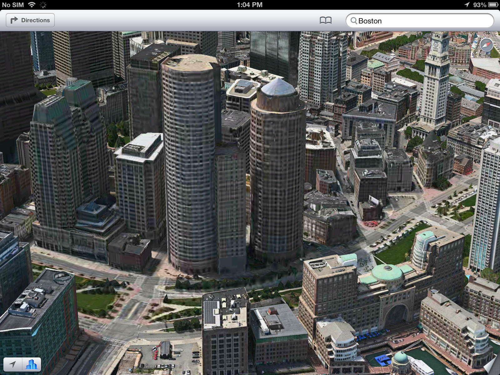
Google and Apple have now released their latest 3D map offerings for the iOS market. Both Google Earth and Apple Maps now provide competing auto-generated imagery for a number of major US cities. Apple's new Maps introduces a fresh user interface for navigating a 3D city and from a commercial real estate perspective, Apple provides higher quality building imagery than what is currently available with Google's auto-generated, mesh-based, 3D buildings. 

Below are examples of the difference in building imagery quality between Google Earth and Apple Maps on the new iPad. Note that Google's 3D buildings appear the same on the Android version of Google Earth as they do on iOS.

One America Plaza, San Diego:
Google Earth 
Apple Maps
One and Two International Place, Boston:
Google Earth
Apple Maps

Washington Mutual Tower, Seattle:
Google Earth
Apple Maps
Apple's Maps do not currently allow users to load any external data. This means that only content provided by Apple can be viewed on the map. Currently this is limited to location information provided by Yelp and vehicle traffic data. The latest version of Google Earth for iPad does allow users to load external data, enabling use with a platform like Cube Cities. Below is an example of how Cube Cities can visualize building data for an office property downtown San Diego, on iPad. 

Cube Cities + Google Earth
As Google and Apple add 3D city coverage to their mobile maps the fidelity of both services will likely improve. At present, Google Earth for iPad (using external data from Cube Cities) is a more effective tool for analyzing commercial real estate, however Apple's building imagery is generally higher quality and available in more cities. New York and Chicago are noticeably missing on Google Earth for iPad but are available in 3D with Apple Maps.

18 September 2012

The Skylines of Cube Cities

The Cube Cities technology platform allows for the rapid generation of city visualizations. This capability allows us to create amazing views of cities to illustrate urban density and building usage. In our cities with data coverage, we track existing structures, construction projects and proposed developments. All of these can be explored on our website with our Skylines page.
Lower Manhattan
Chicago's Loop
Downtown Toronto
Click here to visit our Skylines page to see these city views. Selecting any building will open a menu that links to the building's Grids page, showing where any available leases are located and allowing users to share building information.

12 September 2012

Creating and Sharing Flights with Cube Cities

Users who add available space to Cube Cities can create automatic tours of their space options called Flights. With Flights, users add their available spaces to a Flight, provide it with a name and description, set the correct play order and play the flight.


When played, the Flight will automatically fly to the city view, the market view and then the building view for every space option. The Flight will pause at every available space and display the floorplan and other images associated with the space.


Flights are created as unique URL links that users can share with anyone for free. Cube Cities also makes it easy for users to email and Tweet their Flights. To create a Flight and share space optons today, simply create a Cube Cities account and add any available office or retail space.

5 September 2012

Markup Building Windows in Google Earth with Grids + See the View from Any Grid

Cube Cities provides a free service called Grids. Grids allows anyone to select a building and mark it up with a red pattern to identify areas of interest on a building. Simply click the city icon on the Grids page and then select a building to markup.


If you're signed in you can save the Grids you select, add a note and share this information with anyone via email or Twitter. The special link created by the Grids page also stores the same view of the building, so you can highlight building areas at street level or choose to showcase an area that might be hidden from the first view of the building.


Users can even see the window view from any selected Grid, just select the eyeball icon and the view will automatically move to the exact view from that building location.